Ongerscheide zwesche Versione vun dä Sigg „Šiprage“
Inhalt gelöscht Inhalt hinzugefügt
De Sigg wood neu aanjelaat met däm Aanfang: thumb|260px|left| thumb|left|200px|| [[File:Coat of arms of Bosnia and Herzegovina.svg|thumb|100px|] … |
BBKurt (Klaaf · Beijdrähsch) Jätt ömjeschrävve |
||
| Reih 1: | Reih 1: | ||
{{Atikel_op|Stolberjer Platt}} |
|||
[[File:Siprage.jpg|thumb|260px|left|]] |
[[File:Siprage.jpg|thumb|260px|left|]] |
||
[[File:Siprage-karta.jpg|thumb|left|200px||]] |
[[File:Siprage-karta.jpg|thumb|left|200px||]] |
||
[[File:Coat of arms of Bosnia and Herzegovina.svg|thumb|100px|]] |
[[File:Coat of arms of Bosnia and Herzegovina.svg|thumb|100px|]] |
||
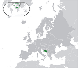
[[File:Location Bosnia-Herzegovina Europe.png|left|thumb|250px|]]'''Šiprage''' es |
[[File:Location Bosnia-Herzegovina Europe.png|left|thumb|250px|]]'''Šiprage''' es ön Siedlung ä [[Bosnie-Herzejowina]], önö Staat ä [[Europa|Südeuropa]].<ref>http://www.kartabih.com/</ref><ref>Vojnogeografski institut, Ed. (1962): Šiprage (List karte 1:25.000, Izohipse na 10 m). Vojnogeografski institut, Beograd / Military Geographical Institute, Ed. (1962): Šiprage (map sheet 1: 25.000, Contour lines at 10 m). Military Geographical Institute, Belgrade.</ref> |
||
* |
*Breetejraad: 44°27'56″ |
||
* |
*Längejraad: 17°33'36″ |
||
* |
*Hüüde: 507-520 m |
||
== Referenzen== |
== Referenzen== |
||
<references/> |
<references/> |
||
De Version vum 27. Aprel 2017 öm 05:30 Uhr
He die Sie ös op Stolberjer Platt
(Sije op Stolberjer Platt)
un jeschrieve wie moch öt kallt
(Sije jeschrieve wie moch öt kallt)
(Sije op Stolberjer Platt)
un jeschrieve wie moch öt kallt
(Sije jeschrieve wie moch öt kallt)


Šiprage es ön Siedlung ä Bosnie-Herzejowina, önö Staat ä Südeuropa.[1][2]
- Breetejraad: 44°27'56″
- Längejraad: 17°33'36″
- Hüüde: 507-520 m
Referenzen
- ↑ http://www.kartabih.com/
- ↑ Vojnogeografski institut, Ed. (1962): Šiprage (List karte 1:25.000, Izohipse na 10 m). Vojnogeografski institut, Beograd / Military Geographical Institute, Ed. (1962): Šiprage (map sheet 1: 25.000, Contour lines at 10 m). Military Geographical Institute, Belgrade.
Weblink
- http://opstinakotorvaros.com/
- http://www.maplandia.com/bosnia-and-herzegovina/republika-srpska/siprage/ Maplandia
- http://www.satellitecitymaps.com/europe-map/bosnia-and-herzegovina-map/federation-of-bosnia-and-herzegovina-map/%C5%A1iprage-map/
- http://www.distancesfrom.com/distance-from-Siprage-to-Banja-Luka-Bosna-i-Hercegovina/DistanceHistory/5243320.aspx
- http://www.udaljenosti.com/bosna/- Distances in B&H
