
Datei:Winterwaroverview.JPG
Ojinaal-Dattei (615 Pixelle breed × 939 Pixelle huh, de Datei hät 139 KB, de MIME-Zood es: image/jpeg)
Beschrievungstex un Zosammefassung
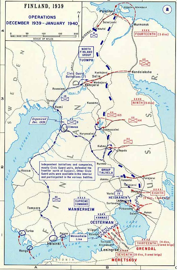
| Zosammefassung | Map of the first phase of the Winter War 1939-40. |
| Et Dattum | Dattum onbikannt |
| Quell | http://www.dean.usma.edu/history/web03/atlases/ww2%20europe/ww2%20europe%20pages/ww2%20europe%20map%2016.htm |
| Dä Urhävver | The Department of History at the U.S. Military Academy |
| Zohshtemmung (Di Dattei och anderswo bruche) |
Public domain |
Background information:
In 1938 the predecessors of what is today The Department of History at the United States Military Academy began developing a series of campaign atlases to aid in teaching cadets a course entitled, "History of the Military Art." Since then, the Department has produced over six atlases and more than one thousand maps, encompassing not only America’s wars but global conflicts as well.
In keeping abreast with today's technology, the Department of History is providing these maps on the internet as part of the department's outreach program. The maps were created by the United States Military Academy’s Department of History and are the digital versions from the atlases printed by the United States Defense Printing Agency. We gratefully acknowledge the accomplishments of the department's former cartographer, Mr. Edward J. Krasnoborski, along with the works of our present cartographer, Mr. Frank Martini.
Please be aware that these maps are large in file size and may require substantial download times.
Lizänz
Dieses Bild wurde von einem Mitglied der United States Army während der Ausführung seiner Dienstpflichten erstellt. Als eine Arbeit der Bundesregierung der Vereinigten Staaten ist dieses Bild in public domain.
|
 |
De Väsjohne vun dä Dattei
Di domohlije Version kriß De jezeich övver dä Link op em Dattum.
| Väsjohn vom | Minni-Belldsche | Pixelle Breed×Hühte (Dateiömfang) | Metmaacher | Aanmärkong | |
|---|---|---|---|---|---|
| Von jetz | 18:38, 1. Okt 2007 | | 615 × 939 (139 KB) | Nasiruddin | *Description : Map of the first phase of the Winter War 1939-40 *Source: [http://www.dean.usma.edu/history/web03/atlases/ww2%20europe/ww2%20europe%20pages/ww2%20europe%20map%2016.htm *Background information: ''In 1938 the predecessors of what is today T |
Jebruch
Heh kütt di Sigg, di op heh di Dattei lengke deiht:
Jemeinsam jebruch Dateie
Heh di ander Wikis bruche di Dattei:
- Der Jebruch op ar.wikipedia.org
- Der Jebruch op bat-smg.wikipedia.org
- Der Jebruch op de.wikipedia.org
- Der Jebruch op en.wikipedia.org
- Der Jebruch op es.wikipedia.org
- Der Jebruch op et.wikipedia.org
- Der Jebruch op fr.wikipedia.org
- Der Jebruch op hr.wikipedia.org
- Der Jebruch op lt.wikipedia.org
- Der Jebruch op lv.wikipedia.org
- Der Jebruch op nn.wikipedia.org
- Der Jebruch op no.wikipedia.org
- Der Jebruch op ru.wikipedia.org
- Der Jebruch op sq.wikipedia.org
- Der Jebruch op uk.wikipedia.org