
Datei:Norway - Location Map (2013) - NOR - UNOCHA.svg

Ojinaal-Dattei (SVG-Datei, de Basis es 250 Pixelle breed × 251 Pixelle huh, dä Dateiömfang es 1,13 MB)
_-_NOR_-_UNOCHA.svg)
Beschrievungstex un Zosammefassung
| Zosammefassung |
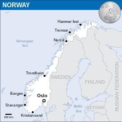
English: Locator map of Norway. |
| Et Dattum | |
| Quell |
English: Norway Locator Map (ReliefWeb) |
| Dä Urhävver | |
| SVG‑Erstellung |
Lizänz
- Ühr hat de Freiheit:
- dat Werk aan Andere wigger ze jävvee – dat Werrek zu koppeere, ze verdeijle, un ze övverdraare
- et neu affzemesche – dat Werk aanzepaße udder zeräsch ze maache
- Onger dä Bedengung(e) dat:
- Namensnännong – De moß däm singe Name nänne en dä Aat, wi dää, dä et aanjevange hät, udder dää, dä de Rääschte jez hät, dat faßjelaat hät, ävver nit op en Aat, di mer esu vershtonn künnt, wi wann dää Desch, udder Dinge Jebruch, dän_De vun däm Werrek mähß, joot'heiße udder aan'äkänne dät.
 This map is part of a collection of 216 free country maps, created by the UN Office for the Coordination of Humanitarian Affairs (OCHA), to be used in print, web or broadcast products.
The ReliefWeb Location Maps released here are maps that highlight a country, its capital, major populated places and the surrounding regions. Attribution Requirements
Using the map without modifications: ensure that the sources and the disclaimer are below the map. Credit as follows: "Credit: OCHA". For use with alteration: remove the OCHA logo and disclaimer following any modification to the map, but keep the data sources as mentioned below the map. Credit the modified map as follows: "Based on OCHA map". You are responsible for the content of your map. We are keen to receive your feedback and hear how you used OCHA's maps. We would be grateful if you would notify us by e-mail and share your work with us. UN Disclaimer
The designations employed and the presentation of material of this map do not imply the expression of any opinion whatsoever on the part of the Secretariat of the United Nations concerning the legal status of any country, territory, city or area or of its authorities or concerning the delimitation of its frontiers or boundaries. |
De Väsjohne vun dä Dattei
Di domohlije Version kriß De jezeich övver dä Link op em Dattum.
| Väsjohn vom | Minni-Belldsche | Pixelle Breed×Hühte (Dateiömfang) | Metmaacher | Aanmärkong | |
|---|---|---|---|---|---|
| Von jetz | 05:46, 1. Feb 2023 | | 250 × 251 (1,13 MB) | Illchy | File uploaded using svgtranslate tool (https://svgtranslate.toolforge.org/). Added translation for id. |
| 22:01, 25. Mai 2022 |  | 250 × 251 (1,13 MB) | Nyilvoskt | File uploaded using svgtranslate tool (https://svgtranslate.toolforge.org/). Added translation for id. | |
| 10:11, 1. Sep 2016 |  | 250 × 251 (1,14 MB) | Wereldburger758 | Resized page to drawing. Removal watermark. Validation of image. | |
| 02:40, 8. Mai 2014 |  | 254 × 254 (1,11 MB) | UN OCHA maps bot | == {{int:filedesc}} == {{Information |description={{en|1=Locator map of Norway.}} |date=2013 |source={{en|1=[http://reliefweb.int/map/norway/norway-location-map-2013 Norway Locator Map (ReliefWeb)]}} |author={{en|1=[[w:en:United Nations... |
Jebruch
Nix Lengk op heh di Dattei.
Jemeinsam jebruch Dateie
Heh di ander Wikis bruche di Dattei:
- Der Jebruch op ban.wikipedia.org
- Der Jebruch op en.wiktionary.org
- Der Jebruch op gor.wikipedia.org
- Der Jebruch op id.wikipedia.org
- Der Jebruch op incubator.wikimedia.org
- Der Jebruch op min.wikipedia.org
_-_NOR_-_UNOCHA.svg)